FIRST ALERT: An enhanced risk for severe weather beginning later today
Published 9:24 am Monday, March 19, 2018
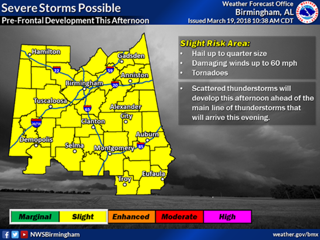
- From the St. Clair Co. EMA:This is the forecast any time after noon today.Slight risk for damaging winds up to 60 mph, quarter size hail, and a tornado cannot be ruled out.
BIRMINGHAM, AL (WBRC) –
Not much weather activity is expected early today other than some light showers.
Trending
The forecast models still show very strong instability developing by this afternoon across the entire area.
Most of the day may be nothing more than a pleasant last day of winter but with afternoon and a strong southwesterly wind flow we could see flow we could see explosive thunderstorm development between about 4 and 7 p.m especially along and northwest of I-59 corridor.
The atmosphere at this time will be conducive to the formation of large to very large hail as well as damaging winds resulting from the down-drafts from thunderstorms which do form. As to the potential for tornadoes, these storms will be most likely to form in the northern parts of our area especially as sunset approaches. The greatest threat for strong tornadoes still appears to be in counties to the north and east.
Stay alert for rapidly changing weather conditions due to these potentially dangerous weather conditions. In areas in the “Slight-Risk” Category storm coverage is expected to be more isolated. Beyond today we see another chance for showers tomorrow but no additional severe weather is expected. Lows may drop to near freezing Wednesday night followed by a slight chance for showers returning by Friday and Saturday.
For St. Clair County, strong storms could affect our area as early as 2 p.m. today. These storms do have the potential of producing tornadoes, according to the National Weather Service.
The strongest storms are predicted to affect St Clair 6-7 p.m. tonight. These are the storms that could produce strong tornadoes, tennis ball size hail, and straight line winds 70 mph or greater.
Pell City Schools and St. Clair County Schools are closing at noon.
St. Clair County EMA has shared a listing of local Community Safe Shelters:
Copyright 2018 WBRC. All rights reserved.
WBRC FOX6 News – Birmingham, AL